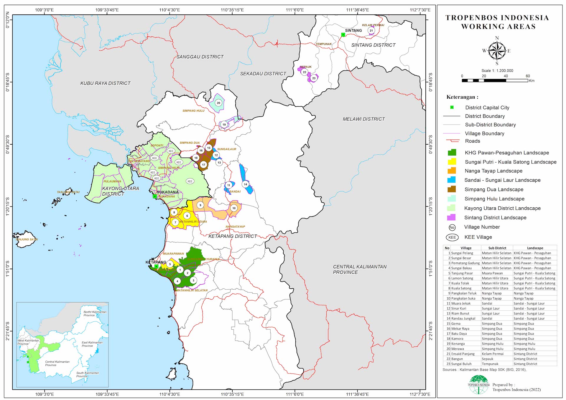
Where we work
During 2022, Tropenbos Indonesia works in Ketapang, Kayong Utara and Sintang Districts, West Kalimantan in a landscape covering an area of 3.5 million ha. In Ketapang District we work in 6 landscapes (Pawan-Kepulu-Pesaguhan, Sungai Putri-Kuala Satong, Nanga Tayab, Sandai-Sungai Laur, Simpang Dua and Simpang Hulu) covering 20 villages, in Kayong Utara District we work in 5 villages, while in Sintang District we work in 3 villages (See attachment and the map below).
We have three branch offices in Ketapang District, i.e. Ketapang Town, Sandai and Simpang Dua, which our central office in Bogor, West Java.
See: Tropenbos Indonesia Assistance Areas in Villages area in Ketapang, Kayong Utara and Sintang District
The landscape extends from the south-western coastal parts of West Kalimantan, to the hinterlands at the elevation of about 1,400 m above sea level. Land use/land cover in the landscape experienced rapid changes and dynamics in the past two decades and based on the time series analysis from the official national Land Cover Maps from the Ministry of Environment and Forestry (MoEF), 2000, 2009 and 2016, the major land use change comes from the development of oil-palm plantation. Oil-palm development began in early 2000s, started with large scale plantations, followed by independent smallholders’ oil palm gardens which are continuously developed until recently.
The ethnic groups living in the downstream areas of the landscape are Malay, Chinese, Dayak, Javanese and Sundanese, while in the upstream areas is dominated by Dayak (Landscape Sandai - Sungai Laur, Simpang Dua and Simpang Hulu). They live as farmers, workers of agro-commodity oil-palm plantations, traders and entrepreneurs, miners in bauxite and illegal gold mining, fishermen, and small-scale loggers. As strategic areas for industries and trades, the landscape has attracted many investors which like a double-edged knife, can be beneficial but also threatening and giving pressure to this area.
Since 2013, fire has occurred every year during the dry months of August and September, with the most massive fire events occurring in 2015 and 2019. Peatland fires create prolonged small flames with thick and persistent smoke, causing heavy pollution, low visibility and haze problems in the neighbouring districts. Some other parts still have important remaining primary forests, such as Gunung Palung National Park, which face various threats including the expansion of cash crops, and fast development of infrastructure. Land conversion, degradation, and fragmentation of forests are only some impacts with severe consequences for biodiversity and so often lead to environmental catastrophe and people calamity.
Unfortunately, driven by economic issues, the landscape stakeholders are often unaware of the risks of climate change (fires, loss of biodiversity, etc.) resulting from the land use change and their agricultural practices. The development of infrastructure, settlement, business and industries often go with the price of environmental damages. Enforcement on sustainable governance is necessary to reduce the damages and minimize the negative impacts as well as to stop further destructions of the landscape due to unsustainable practices.
To address the situation, continuous efforts must be done involving the whole related stakeholders of the landscape. In the past years, Tropenbos Indonesia has been part of the efforts and in collaboration with other stakeholders of the landscape delivering programmes which have eventual goal of achieving good governance and sustainable landscape, strengthening institutions, and empowering people for climate resilience business. Tropenbos Indonesia has also been part of the establishment of multi-stakeholder working groups at district and inter-village levels of the landscape. With the collaborative efforts and participative measures done by all stakeholders, it is expected that a successful result can be achieved and a sustainable path has been underway even in the midst of rapid development of the area.